Tilicho Base Camp Trek
Overview
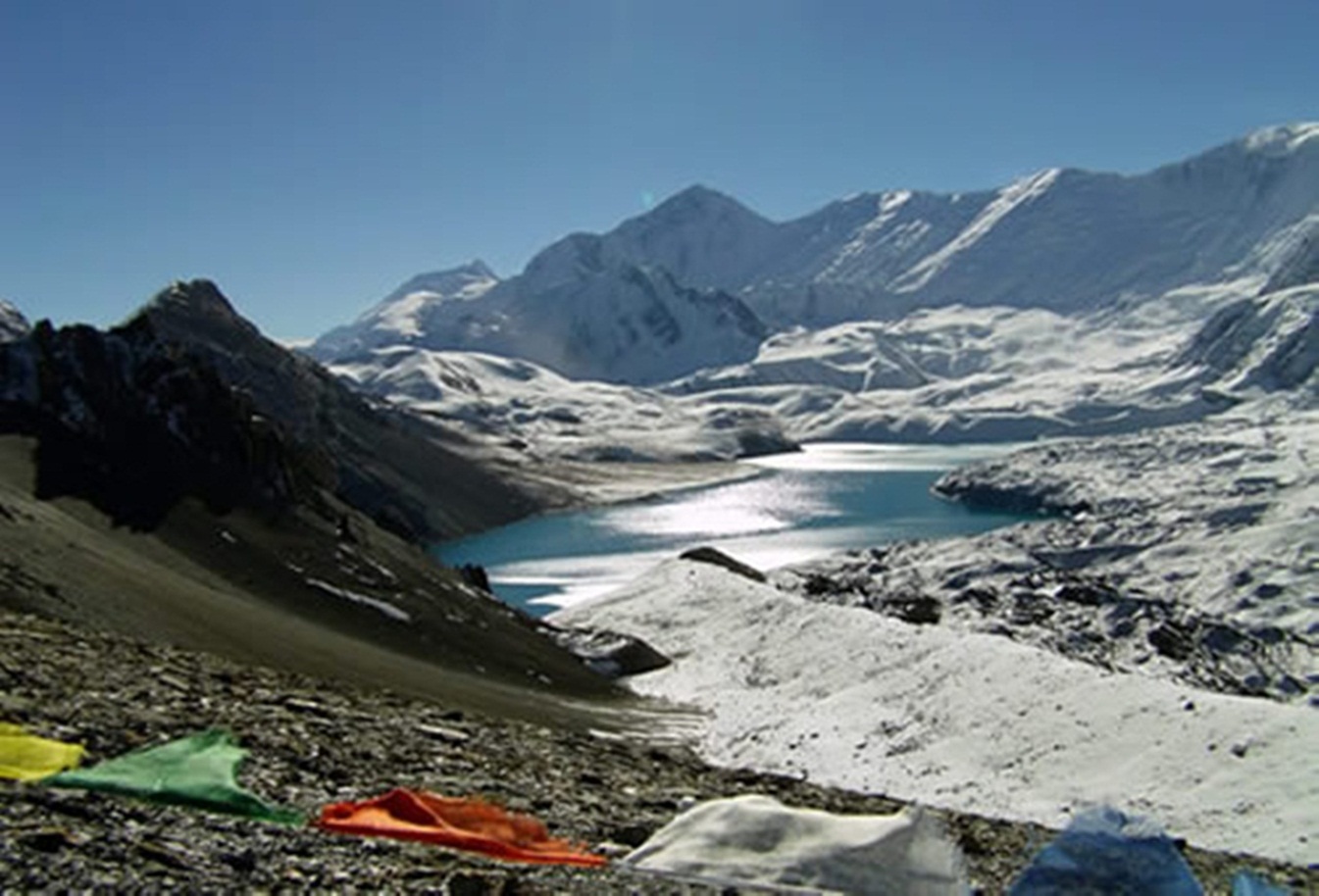
Tilicho Base Camp Trek lies in the Annapurna range of the Central Nepal Himalaya. Lake Tilicho is the highest Lake in the world (4913m). Stretching about 2.5miles / 4km long and about 0.6mile / 1km wide, it lies at the base of the Tilicho peak (7,134m). Tilicho Base Camp Trek is another mystical and romantic trekking destination in Nepal. Tilicho Base Camp Treklies south of Thorong- La between Manang and Jomsom. In the past this trek has been considered off limits, being part of a military training area. However, recently it was realized that the restrictions apply only to part of the area and so it is still possible to trek there without entering the restricted region. Very few people realize this.
This Tarns-Himalayan adventure begins with a spectacular Himalayan views and the Marsyangdi valley from Beshishar for the Tilicho Lake - Mesokanto pass beginning with same trekking route for Annapurna circuit trekking till Manang trail to head up toward Tilicho Lake. These high Himalayan reaches are the habitat of the Himalayan Thar (Mmountain goat) and the snow leopard, among other mammals. From your camp by the shores of the Lake, you will climb up to the Mesokanto-La (5100m) where we are rewarded with the first views of the Kali Gandaki valley. You will descend to stay at the charming Thakali village of Marpha. Here on you follow the Kali Gandaki upstream to Kagbeni, and up a side valley to the shrine at Muktinath, sacred to Hindu and Buddhist pilgrims alike. The trip ends in Jomsom with an early morning flight to Pokhara. Tilicho Lake trekking route goes along the Marshangdi River and Gorge through the remote valley of Manang also known as the district behind the Mountains, to crest the arid, windswept northern flank of Annapurna at the Thorong-La (5416m). The route then passes through the Khanshar Village. The trail goes through the must challenging pass "Moesokanta Pass" of Annapurna area to Jomsom and continues trail to Gharepani and return trek to Pokhara..
Highlights
- Rim of the Kathmandu valley
- Various ethnic backgrounds, Brahmin-Chettri, Gurung, Manangi, Thakali and Tibetan
- Explore beautiful Manang Village.
- Crossing, Eastern pass [5340m] and Masokanto-La (5099m)
- Wonderful Tilicho Lake
- Magnificent views of Lamjung Himal, Annapurna Himalayan range, (I,II,III,IV),Mt. Nilgiri, Mount Manaslu , Dhaulagiri Himalayan range
- Muktinath temple, one of Hindu's most revered sites
- One of the world's highest pass Thorong-La [5416m]
- Journey through deepest gorge of the world, Kali Gandaki Gorge.
- Restful hot spring
- Magnificent Himalayan sunrise sight from the Poon hill.
- Lake valley of Pokhara.
Trip Summary
| Trip Grade | Moderate to Strenuous |
|---|---|
| Trip Duration | 20 Nights/21 Days |
| Trip code | NAP-TBC-105 |
| Trip Start/Ends | Besishahar - Chamje/Jomsom - Pokhara |
| Maximum Altitude | Thorong -La pass (5416m) |
| Trip Cost | Prices on request |
| Group Size | Minimum 2 upto 16 persons in one group |
| Accessibillity | Drive to Bhubule/Khudi to trail-head from Kathmandu, start the trek according to the itinerary, after Thorong-La pass continue trek to Ghorepani and return trek to Pokhara. |
| The Route | Maximum altitude (5416m) Thorong -La passes 5-6-hrs average walking per day |
| Season | Sept – Nov / March - April |
| Trip Facilities | 3+ hotel in city on B/B and best available teahouse/lodge on mountain, camping required for Mesokato-La pass. |
Itinerary

Upon our arrival in the Tribhuwan International Airport (TIA) in Kathmandu, we will be greeted by a representative from Nepal Adventure Point who will drop us off at our hotel. After checking in, we take a rest or we may also stroll in the streets of Thamel, a tourist hub in Kathmandu for some souvenir shopping.
After breakfast the day will start with a guided tour of Kathmandu's historical and spiritual key attractions; including the historic Kathmndu Durbar Square, the famous 'Monkey Temple' (Swayambunath) and then finally visit to Patan Durbar square which is situated the heart of the city constitutes the focus of visitor's attraction. In the evening there will be pre-trip discussion where you can meet your group leader/guide then you can ask any questions you may have.
Starting the day early for the trek would be a good idea; we will travel by road from Kathmandu to Chamje village which will be the starting point of the trek. Chamje is a small village in the Annapurna Region at an elevation of 1430 meters. There is a waterfall which is an attraction for both locals and tourists alike. The beautiful greenery all around will fuel us for the trek ahead.
We begin the trek early in the morning. The trail takes us through various vegetable plantations, waterfalls and mixed communities that are believed to have migrated from Tibet. After crossing the suspension bridge below Chamje and climbing two steep sections, we reach the village of Tal. From Tal, we enter the Manang District. On the way we also pass through Kodo village and walk on the trail that rises and falls and cuts across a mountain side to one of the biggest villages in the Manang district, Dharapani.
Today we negotiate a few steep, forested ridges along with several landslides on route to Chame. We should not forget to look up though, as we will be greeted with remarkable views of Lamjung Himal, Annapurna II, and Annapurna IV (7,525m). We also come across small hot springs which will be a sweet respite from the tiring trek and help us relax for a while. Chame is the headquarters of Manang District in the Gandaki Zone of northern Nepal Overnight in Chame.
Today the trail continues up and down, passing several rivers and sparsely populated settlements. We walk through a steep and narrow valley to have our first view of Paungda Danda rock face, a dramatic curved rock face rising 1500 meters from the river. From here, we also gain excellent views of Annapurna II to the south and Pisang Peak to the north east. We descend to the Manang Valley floor enjoying the captivating landscape.
From Pisang there are two routes to Manang. We choose the one which passes through Upper Pisang via Geru as it guarantees outstanding views of Mt. Annapurna, Pisang Peak, and others. As we near Manang, the climate becomes colder and drier. However, a short visit to Barge Monastery, the biggest monastery in the Manang District, should cheer us up.
There are two different routes from Pisang: a low road and a high road, if we go to the high route. First we climb to the village of Ngawal at (3657m) before reaching Ghyaru and onto Pisang. The mountain scenery is along this route is superb. Ngawal is a medieval village, with flat roofed stone buildings and ladders to reach the living quarters. From here, we continue to climb to Ghyaru at (367
his day is acclimatization day, which is best spent being active and climbing to higher elevations for views but returning to lower altitudes to sleep. Manang itself is in a spectacular location with many attractions. There are lakes, caves, moraine-hills, monasteries or local activities in town and visit HRA clinic that may be advice for any one going high for trekker’s safety.
After acclimatized at Manang we continue our adventure for Tilicho Lake, from Manang one heads out through the western gates and then one follows the path down to the river. After crossing the the Khangsar Khola on the bridge below Khangsar and ascend the slope to the village, a village still in the old Tibetan style and which is also known as last village of Nepal
.Continue from Khangsar on a large path. Pass a Gompa (monastery). The route ahead goes on a recently constructed path up towards a high ridge. At one point is an intersection. One path maintains the altitude, traversing the slopes towards a place where the valley is narrow; the other continues to ascend towards the line of the ridge. The former is the old path, and is much more difficult as it goes on really steep screed; the latter is the new path that goes a completely different way. Continue along the new path, reach a high crest, and descend on switch backs carved out through the screed slopes to a side valley of the main valley. At its bottom is a brook. On the other side of it is a building known as Tilicho Base Camp at elevation of 4200 meters.
Today our journey start early in the morning around 6 AM as we trying to avoid the wind. From Base camp to the Tilicho lake takes another 3-4 hours. Tilicho Lake is a cold barren place in the afternoon and claimed as highest lake of the world. After we spend some time around Tilicho Lake we will return same way back to Base Camp as there are no any accommodation facilities at Tilicho Lake area.
Returning from Base camp you can keep high and follow a track 400meters or so above Khangsar village passing through the ruins of old Khangsar and follow an unmarked trail which will lead you around and down to cross the river on an old log bridge between Gumsang and Yak Kharka.
It's a tough stage at first involving a 300m ascent to a ridge high above the lake. The traverse includes a couple of ridge crossings before a short steep ascend to the Mesokanto La. From the pass anticipate views that stretch back to the lake as well as views to the Nilgiri peaks and Dhaulagiri on the far side of the Kali Gandaki Gorge. From the Mesokantu La there is a steep – sometimes under&
Today is a long trek starting before sunrise at 4 am to reach the pass by 9-10 am otherwise weather conditions will greatly affect the journey. We cross over at an altitude of 5416 meters we can be exposed to strong winds if crossing too late. We start to climb steeply that is regularly used and easy to follow. However, the problem may arise due to the altitude and snow. It often causes terrible problems to cross the pass if it is covered by snow but it is all depending on the weather condition. About four hours climb up to the pass marked by the chortens & prayer flags. As you reach the top, you are rewarded by the magnificent view from the top with another 4 hours trek will take to the holy town of Muktinath. Muktinath means place of Nirvana and is home to the Muktinath temple as well as several monasteries. It is said that all sorrows you feel are relieved when visiting the Temple, which is a scared pilgrimage site to both Hindus and Buddhists. The main pilgrimage normally takes place in September. The Temple is dedicated to Lord Vishnu and has 108 waterspouts around it from which Holy water pours. Another attraction nearby is the Jwala Mai Temple this contains a spring and an eternal flame fed by natural underground gas.
From Jomsom the trail forwards to Marpha (2680m), the large Thakali village. Passing the agricultural projects then you will reach to Tukuche Distillery and the Thakali village of Tukuche (2580m). Crossing the Tha Khola you will come to Khobang.. Then crossing the stream and passing the local school you will reach to Larjung. From Larjung the trail proceeds through the forest and reaches to Dha
Making several ups and downs the trail reaches to Kiaku (2180m). From Kiaku the trail crosses the ridge and reaches to Ghasa. The route crosses the Kaligandaki River on a suspension /pidge and descends to Thapla (1890m). Making a steep and rocky decent you will reach Kopchepani and Rupse Chhahara where you can see the beautiful water fall. From Rupse Chhahara walking about thirty minutes you wi
From Tatopani the trail again crosses the river and then climbs Shikha, a large and prosperous Magar village and forwards to Phalate. Beyond Phalate you will meet the trail junction and going further you can get to Chitre. The trail forwards through rhododendron and Mongolia forest and finally reaches to Ghorapani.
Early in the morning you can climb about one hour to Poon Hill (3210m), the viewpoint for sunrise taking in the views of Mount Annapurna, Dhaulagiri, Nilgiri, Himchuli and Machhapuchchhre. Return back to the Hotel for /peakfast. After /peakfast you will climb to Gurung Hill, crossing pine and rhododendron forest’s with excellent views you will trek down to Deaurali (3190m), then further trek do
Cost Included
- Fee: ACAP entrance permit and TIMS card
- Activities: Sightseeing and trekking trip as per the itinerary.
- Accommodation: 3 nights hotel in Kathmandu, 1 night hotel in Pokhara on twin sharing and 16 nights teahouse/lodges on twin or mult share bedroom on mountain
- Food: Full board on teahouse (Breakfast, lunch and dinner]) during the trekking and 4 breakfast in city.
- Staffs: Leader/Guide and supporters and their daily wage, food, and accommodation
- Transportation: Airport arrival/departure transfer, Kathmandu to Beshisahar, Nayapul to Pokhara and Pokhara to Kathmandu transportation.
- Company & Government’s service charge: All applicable Government taxes & official service charges. And Crew’s, daily wages/salary, food, equipment, air and road-head transportation
Cost Excluded
- International and local flights
- Travel/medical insurance coverage personal accidents, medical and emergency Helicopter rescue
- Personal travel and trekking equipments
- All lunch and dinner while in city
- Items of a personal nature such as normal drinks, hot shower, dessert, laundry, internet and phone call.
- Expenses occurred due to unavoidable Events i.e. road wrecks, flight delays etc.
- Tips/Gratuities for your trekking crews
- Temple and Monastery entrance fees
- Optional activities
- And unforeseen expenses which are out of control by Nepal Adventure Point
Trip Notes
Please request our Trip Note advice and detailed itinerary.