Dolpo via Jumla Trek
Overview
Dolpo via Jumla trek is located inside the Shey-phoksundo National Park of mid-western Nepal, behind the Dhaulagiri massif towards the Tibetan Plateau. This region was opened up in 1989 to organized trekking groups and to individual trekkers in 1990. There are Tibetan style inner Dolpo villages in Tarap, but most of the southern part of Dolpo is a region of Hindu influence.
Dolpo is located inside the Shey-phoksundo National Park of mid-western Nepal, behind the Dhaulagiri massif towards the Tibetan Plateau. It is a virgin and divine land and truly an isolated corner of Trans Himalayan Zone. There the nature seems to have remained exactly the same as it was first created, unharmed and unaltered. People here still lead primitive life, but they are very friendly. This is also one of few areas where pre-Buddhist Bon Po religion is still practiced. One of the main attractions in Dolpo is Phoksundo Lake and its waterfall. The lake at (3627m), is the deepest lake in entire Himalayan Region. Nature created a unique and wonderful treasurer like Dolpo, which is being the shelter of many rare alpine living beings. In spite of tough trails and rugged topography journey to Dolpo area is a life time experience. Tourists rarely visit Dolpo Region and the trekking route is very narrow and steep at some places, so good hiking experience is essential for this trek
The trek begins from Jumla, walk through Nepal's wildest with its strange mixture of ethnic Groups, offering allots of altitude scenery. A high route to Dolpo from Kaigaon leads across the Kagmara-La (5115m).The pass is not difficult to cross but in the winter snow bounds and potentially dangerous from November to early March Kagmara-La. We continue trek to Ringmo and ascent to Baga-La (5180m), which is the highest point of the trek. We then continue, Numa-La, Dho Tarap, Tarakot to Juphal, where we catch the flight to Kathmandu via Nepalgunj.
Highlights
- Rim of the Kathmandu valley excursion
- Trekking alone with local Village and culture
- Visit Rara Natinal park
- Challenging special trek observe the remoteness of Nepal
- Snow capped Himalayan peaks
- Ancient trans-Himalayan caravan route and isolated villages
- Spectacular Lakes, Enthralling Tibetan culture and tradition
- Earliest Bon-Po culture, Buddhist Monastery and Tibetan life-style
- Lake Phoksundo
- Seeing the people and settlement among highest in the world
Trip Summary
| Trip Grade | Moderate to strenuous trail. |
|---|---|
| Trip Duration | 23 Nights/24 Days |
| Trip code | NAP-LDOL-408 |
| Trip Start/Ends | Kathmandu, Nepalgunj/Nepalgunj, Jhupal |
| Maximum Altitude | Crossing Kagmara-La (5115m Numa-La Pass (5238m), Baga-La pass (5214m), |
| Trip Cost | Prices on request |
| Group Size | Minimum 2 upto 16 persons in one group |
| Accessibillity | Kathmandu fly Nepagunj and Jumla from Kathmandu |
| The Route | Maximum altitude upto Crossing Kagmara-La (5115m Numa-La Pass (5238m), Baga-La pass (5214m), 5/7-hrs average walking per day, Moderate to Strenuous trail. |
| Season | Aug-Nov and Mar-May |
| Permit Fee | Per week per person US$ 10 or equivalent convertible foreign currency. |
| Trip Facilities | 3+ hotel in city on B/B and home-stay/camping on mountain |
Itinerary

Arrive in Kathmandu: Upon arrival at Tribhuwan international airport, welcomed by our representative and transfer to hotel. The remainder of the afternoon is at leisure. A pre-trek briefing will be given in the evening at hotel about the daily program activities by your Group Leader/Guide.
After breakfast the day will start with a guided tour of Kathmandu's historical and spiritual key attractions; including the historic Kathmndu Durbar Square, the famous 'Monkey Temple' (Swayambunath) and then finally visit to Patan Durbar square which is situated the heart of the city constitutes the focus of visitor's attraction. In the evening there will be pre-trip discussion where you can meet your group leader/guide then you can ask any questions you may have.
As per the flight schedule for Nepalgunj we transfer to the domestic airport for one and half hour scenic flight to Nepalgung. At Nepalgunj we will have time in the late afternoon or evening to have a look around the town which is situated on the southern Nepal border with India. Here it is quite hot and tropical in character.
This morning we fly from Nepalgunj to Jumla. We will meet our trekking crew and make the final preparations and leaving Jumla, we cross the Tila Khola and the Chaudabise Khola near their confluence and climb gradually to a fertile valley of rice terraces. The trail continues through several villages before passing through a forest of maple and walnut to a meadow which, in season, is covered in wildflowers. Beyond the meadow, the trail climbs to a small pass before descending again to Gothi Chaur and our first night's camp.
We will re-enter the Tila river valley and follow this river slowly to its source. After ascending through fields of barley and buckwheat we arrive at the trail junction at Muni Sangu, a small settlement where we can see peculiar carved wooden faces, called dok-pa and are supposed to offer protection from evil spirits. These faces can be seen throughout the whole Dolpo region. We stay on the southern side of the river from here as the valley slowly becomes narrower and follow our way to Changrikot. The trail then finally crosses the river and climbs towards the grey stone houses of Chotra (3010m). The village has typical Mani walls and a kani over the trail. A short distance from here is the Tibetan settlement of Naphukana where we will make our camp.
The trail becomes steeper today as it climbs past rocky fields to forests of oaks and birch trees strangled with strongish moss. The climb will end at the Mauri Lagna (Honey pass) at 3820 meter. From this pass we have good views of the snowy peaks of Gutumba (5608m) and Mataumba (5767m) to the north-east and Bhalu Himal (5460m) to the south. We will descent from here to the Bheri valley to the large Khampa settlement of Chaurikot at 3060 meter. A short time past this village there are some excellent campsites alongside the trail.
We will continue our trek through walnut forests; the local people seldom eat the nuts but use them as a source for cooking oil. We slowly descend to the village of Rimi at 2890 meter, where the amusing faces of the dok-pa peek at us from the tops of houses. After crossing the stream we will arrive in Kaigaon, where we will find the first shop since leaving Jumla
We follow the west bank of the Bheri River and climb slowly up leaving the river deep below us. The trail stays high above the river and continues to the confluence where the Jagdula and Garpung Kholas join to form the Bheri. We then drop to the Jagdula Khola River and cross it on stones to our campsite near the army post at Toijem.
This day we follow the trail up the western side of the Garpung Khola River to about 3650 meter, after which we cross it and continue upstream on the eastern side. The valley narrows and the river becomes a series of waterfalls as the trail climbs to a moraine at 3900 meter. We will make a high camp in the boulders at Kagmara Phedi. The panoramic views of the peaks from here are sensational. Wildflowers are of the hardy alpine species, including blue poppies, buttercups, mint, gentians and puffballs. Among the birds here you may sight snow pigeons, redstarts, ravens and griffons. This is also an excellent place to spot blue sheep.
We start early to climb alongside the Kagmara Glacier to Kagmara La pass at 5115 meter. Then we descend about 900 meter along a stream into the Pungmo valley. On this side of the pass there are sweeping scree slopes and massive rock formations that contrast with the vertical uplifts and thrusts of the southern side. We descend further to Lasa, a shepherds’ camp at about (4060m).
The trail stays high above the stream, which eventually becomes the Pungmo Khola River. The route enters birch and juniper forests, which give away to blue pines as the trail crosses the river on a wooden bridge. The route continues through barley fields to the fortress-like village of Pungmo. From here we continue our way downstream to the school at Sumduwa and descend to a camp on the banks of the Phoksumdo Khola.
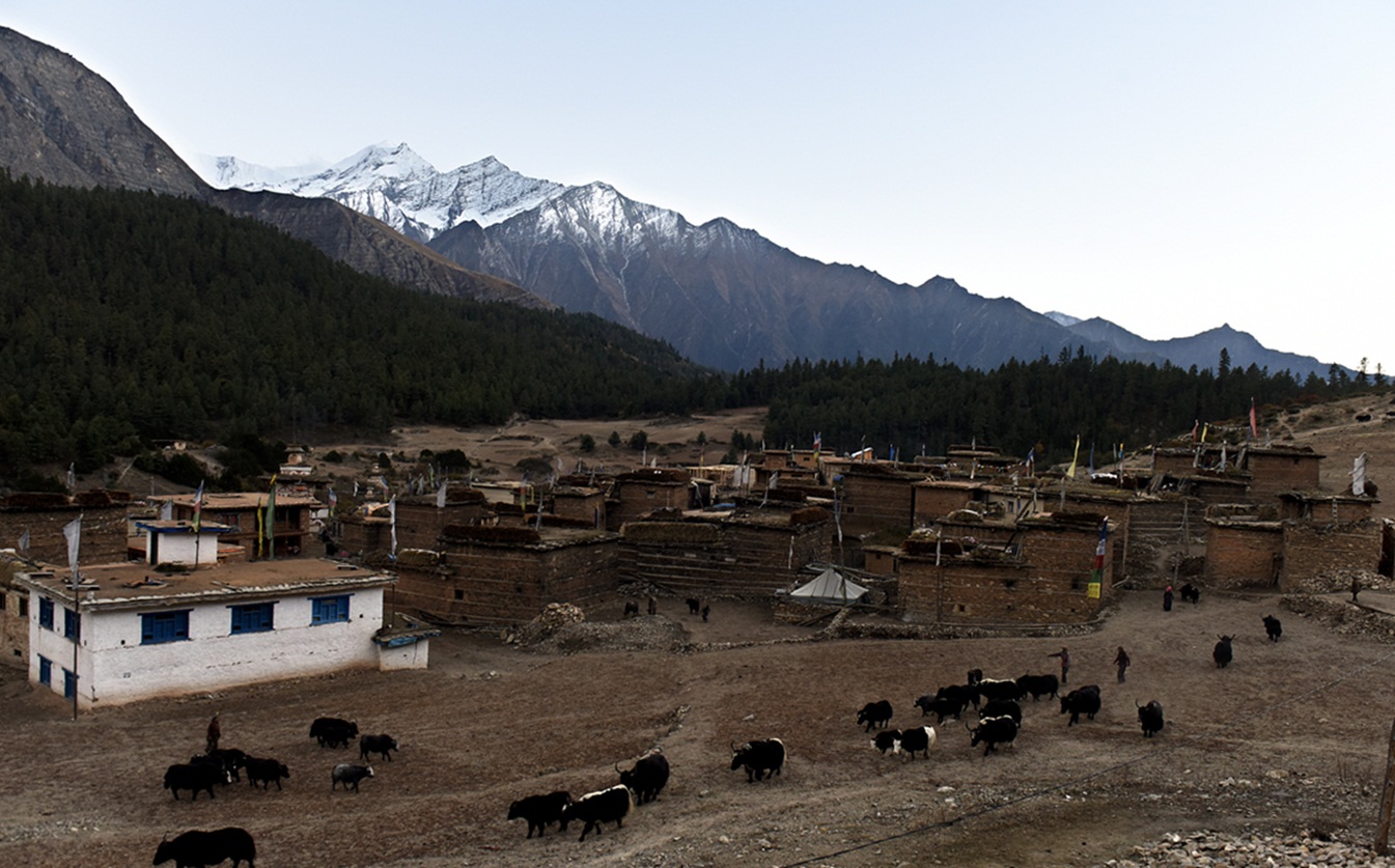
We will join the direct trail to Phoksumdo Lake today climbing through forests of big cedars on to Palam (3710m), a winter settlement used by the people of the Ringmo village. The entrance station for the Shey Phoksumdo National Park is at the south end of the village. The route then descends on switchbacks through open country to an elevation of 3300 meter, and then starts up another set of dusty switchbacks to a ridge at 3780 meter to the highest waterfall in Nepal (200 meter high). Our route then continues on to Ringmo village, a picturesque settlement of flat-roofed stone houses with lots of Mani walls. Just below Ringmo we cross a bridge and follow the trail to Phoksumdo Lake, where we camp at the national park camping grounds west of the Lake. Ringmo is a charming village. People practice the Bonpo religion here. Bonpo is a lot older than Buddhism and goes thousands of years back. It has more animistic aspects than Buddhism. For outsiders it is difficult to see the difference between Bonpo and Buddhism, but one important aspect is that you have to cross their Mani walls and chortens anti-clockwise, while according to Buddhist custom, you pass them clockwise. The women wear dark or checked dresses with colorful aprons made from yak wool. You see fewer men in the typical dress, which is a long coat, from which they let one sleeve hanging down. Strolling around the village, you might see women weaving. In Ringmo women make very nice woven products, like belts, bags, shawls and blankets. Most items are made from cotton, but they also sell products made from yak wool. There are a few shops where you can buy this iteams.
Your body needs time to acclimatize to the higher ltitude. The Phoksundo Lake is such a beautiful place for a free day. There is a beautiful Bonpo Gompa (Monastery) at the shore of the lake, which is worth a visit. It’s a 20 minute walk to the monastery through the pine forest. In the monastery you can observe a statue of Thönpa Chenrab, the founder of Bonpo religion, a Buddha who lived thousands of years ago.
We retrace our route as far as Ringmo and then follow trail eastwards through forests of juniper and blue pine. The trail follows the river up the valley to a waterfall and we will camp here at the base of the Baga-La Phedi.
From our camp it's a steady 3 hour climb to the top of the Baga La, the second of the high passes. The descent is gradual at first but it soon drops steeply to a stream before ascending again to the foot of the Numa-La.
We continue climbing through arid country to the last of the high passes, the Numa-La. It is marked by Mani stones and, if it is clear, we can see as far as Dhaulagiri. Finally we reach at Tokyu, which is said to be the highest permanent settlement in the world. The Gompa is worth a visit. It has a beautiful statue of Maitreya, the Future Buddha.
It’s not far to Dho Tarap. On the way, you pass the Cristal Mountain School, which is educating children from Dho and surroundings. It is a nice school, sponsored by a French NGO. From the school, it’s about half an hour to Dho. At the entrance you pass nice a gate chorten. Also the people of Dho are direct descendents of Tibetans. Besides the typical dark dresses with colorful aprons, most Dho women wear bracelets of big shells and some have beautiful silver and turquoise headgear. Most men have long hair, with a red ribbon in their hair, in the style of Tibetan Khampas. Besides they wear the long coat, from which one sleeve is hanging down. Dho Tarap is a traditional agricultural village, surrounded by fields. Yaks are used to plough the land. As in the other villages you came across, barley, buckwheat and potatoes are among the few crops that can grow here. But nowadays, small greenhouses enable the people to grow some green vegetables as well. Besides, people live from what the yak gives them and from trade. The houses are made of stones found in the river valley and are in typical Tibetan style, with small windows and the flat roofs stocked with firewood. Close to Dho are 2 monasteries which are worth a visit. Ribo Bhumpa Gompa, right on the hill behind Dho, and Shipchaur Gompa, which is in the village Shipchok, 30 minutes walking from Dho. Ribo Bhumpa Gompa belongs to Nyingmapa Buddhism, by the local people called Chöba Buddhism. Inside you find a beautiful big statue of Guru Rinpoche. Guru Rinpoche (Padmasambhava) is a very important Buddhist saint from the 7th century AD. He conquered the demons that were preventing Buddhism to get hold in Tibet and in this way made sure that Buddhism could be introduced in Tibet. You can easily recognize him, by his big eyes, little mustache and the staff with skulls he holds. Next to the Gompa is a chorten with a chorten inside, which is said to hold the remains of a demon killed by Guru Rinpoche. Shipchaur Gompa in Shipchok belongs to Bonpo Buddhism.
Leaving Dho Tarap, you come along many Mani walls and small chortens. The path is going down, following the Tarap Khola. Gradually you can see the landscape changing. After leaving Sisaul, you climb to a small pass with a nice chorten. You mostly walk in the river valley with high rocks towering above you on both sides. The landscape is still pretty barren and this is your last change to see the bluesheep or snowleopard. The path gradually goes down, with some parts going up as well. At some parts the path is beautifully carved out of the rock, so that you are walking in a kind of three sided tunnel and rech at Nawarpani.
After Nawarpani, the landscape gets quickly greener and the path is sometimes going through pine forests, with a wonderful smell. It’s a fairly easy walk over a pretty large path. The path sometimes goes very high above the river. The path goes along the east and west side of the river, crossing the river twice by suspension bridges and we reach at Laina Odar, located at the riverside. From Laina Odar the trail goes down pretty steep to Laisicap (2772 m). Although the trail is generally in good condition, there are a couple of landslide areas where the trail gets very narrow, and where passing is a bit difficult. The landscape is very beautiful. The path goes partly through forests and you are surrounded by steep cliffs full of pine trees, mostly spruce, fir, juniper and cypress, some of which are huge
The first part goes through rough landscape. The path is sometimes carved out of the rocks, and at a few points very narrow. The path goes slightly up and down, following the Thuli Bheri River, once and a while passing a couple of houses. Dunai is the headquarters of Dolpa District. It’s a large village, of about 2.500 people, more or less half Hindu and half Buddhist. Up the hill, there is a Buddhist monastery, which is worth a visit.
It’s a short walk to Juphal. After 45 minutes you reach a beautiful gate chorten which is the entrance to the village development committee of Dunai. Inside the chorten you can observe some beautiful Buddhist paintings of important Buddhist figures and Mandalas.
You pass the big iron suspension bridge, which you crossed on the first day to get into the Shey Phoksundo National Park. It’s about 2½ – 3 hours to Jhupal from the bridge. The first part goes over a large path. After 45 minutes, you pass through the small village Kalagaonda. About 45 minutes later, you leave the main road and walk over a small path, through fields of barley and wheat, with walnut, peach and apricot trees. It’s a pretty steep climb of about 1 – 1½ hour to reach Jhupal. Just before arriving, you pass the Hindu village Dangiwada. Jhupal is a large village with a small bazaar where it is nice to look around.
Early morning, a short scenic flight for thirty five minutes to Nepalgunj, over the Himalayan foothills overlooking stunning views of the main peaks including Annapurna and Dhaulagiri to the north. On arrival at Nepalgunj depending upon the connecting flight schedule to Kathmandu. If it is in the afternoon have time for few hours’ refreshment in the comfort of the Hotel Batika or similar at Nepalgunj. Then connect with the flight back to Kathmandu.
Cost Included
- Documents: Lower Dolpo permit and national park entrance permit
- Activities: Sightseeing,hiking and trekking trip as per the itinerary.
- Equipment: All necessary camping equipments and kitchen utilize.
- Accommodation: 4 nights hotel in Kathmandu, 1 night hotel in Nepalgunj on twin sharing bedroom and 18 nights tented accommodation on mountain.
- Food: Full board on camping (Breakfast, lunch and dinner) during the trekking and 5 breakfast in city.
- Staffs: Leader/Guide and supporters and their daily wage, food, and accommodation
- Transportation: All airport arrival/departure transfer and surface road-head transportation and Kathmandu to Nepalgunj and Jhupal and return flight to Kathmandu
- Company and Government’s service charge: All applicable Government taxes and official service charges. And Crew’s, daily wages/salary, food, equipment, air and road-head transportation
Cost Excluded
- Your international flight.
- Travel/medical insurance coverage personal accidents, medical and emergency Helicopter rescue
- Personal travel and trekking equipments
- Lunch and dinner while in city
- Items of a personal nature such as normal drinks, hot shower, dessert, laundry, internet and phone call.
- Expenses occurred due to unavoidable Events i.e. road wrecks, flight delays etc.
- Tips/Gratuities for your trekking crews
- Temple and Monastery entrance fees
- Optional activities
- And unforeseen expenses which are out of control by Nepal Adventure Point
Trip Notes
Please request our Trip Note advice and detailed itinerary.