Lumbasumba Trek
Overview
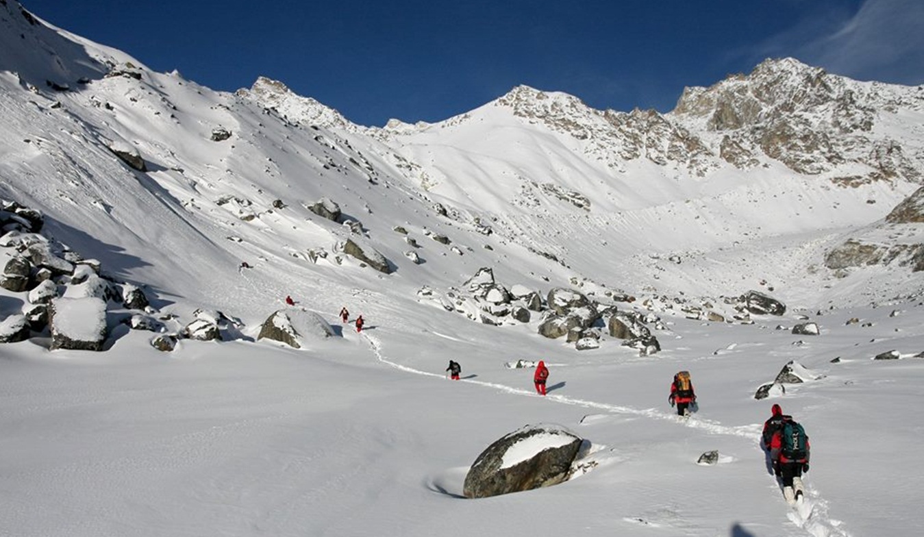
Lumbasumba trek (Kanchenjunga to Makalu) is recently opened. Lumbasumba area is rich in flora and fauna and one can see different birds and wildlife species, including the endangered snow leopard and red panda along the route. There are a number of high mountain lakes in Olangchung Gola. The route goes through two of Nepal’s best preserved protected areas – the Kanchanjunga Conservation Area and the Makalu Barun National Park. Through the route, one can also trek to the base camps of Mt Kanchanjunga and Mt Makalu. Similarly, the Tamor and Arun River systems can be the other attraction for travelers. These two rivers are the major tributaries of the mighty Sapta Koshi River. The route encompasses alpine grass lands, rocky outcrops, dense temperate and sub-tropical forests, and low river valleys. Apart from natural beauty, trekkers can also explore cultural heritage like monasteries, chhortens, temples and prayer walls. And to add to the flavor, the festivals of different ethnic people living in harmony only serve to make the native culture livelier.
Highlights
- Trekking through terraced fields and typical eastern- Nepali villages
- Traditional villages, Unique Himalayan culture with majority of Sherpa, Rai, Limbu, Tamang, Chhetri, Brahamn & Tibetan
- Monasteries, Chortens, Temple & prayer walls
- Occasional sightings of the Snow Leopard and Red Panda
Trip Summary
| Trip Grade | Moderate to strenuous trail. |
|---|---|
| Trip Duration | 21 Nights/22 Days |
| Trip code | NAP-LUB-414 |
| Trip Start/Ends | Kathmandu-Biratnagar-Suketar/ Suketar-Kathmandu |
| Maximum Altitude | (5177m) |
| Trip Cost | Prices on request |
| Group Size | Minimum 2 upto 16 persons in one group |
| Accessibillity | 45 minutes flight to and from Taplejung/Suketar from Kathmandu |
| The Route | Maximum altitude (5177m), 5/7-hrs average walking per day, moderate to strenuous trail. |
| Season | Sept – Nov / March - April |
| Permit Fee | Per week per person US$ 10 or equivalent convertible foreign currency. |
| Trip Facilities | 3+ hotel in city on B/B and home-stay/camping accommodation on mountain. |
Itinerary

Arrive in Kathmandu - Upon arrival at Tribhuwan international airport, welcomed by our representative and transfer to hotel. The remainder of the afternoon is at leisure. A pre trip meeting and briefing will held all together with you at hotel about the daily program activities by company representative and your trip Leader/Guide where you can discuss your final questions all together.
After breakfast the day will start with a guided tour of Kathmandu's historical and spiritual key attractions; including the historic Kathmndu Durbar Square, the famous 'Monkey Temple' (Swayambunath) and then finally visit to Patan Durbar square which is situated the heart of the city constitutes the focus of visitor's attraction. In the evening there will be pre-trip discussion where you can meet your group leader/guide then you can ask any questions you may have
The porters and crew will be waiting for our arrival. After landing we take an early lunch, while the crew arranges our gear. In the afternoon we blow out the cobwebs with an easy 2 to 3 hours walk along the ridge line to Fungling.
The first day trek starts from Fungling (1777m) – the headquarters of Taplejung district. Sherpa Tol is the gateway to this trek. The trek passes through beautiful cardamom fields and Alnus trees (Uttis) until Hangdewa VDC which takes around two and half hours. On the way, there are small tea shops at Asangpati Tole, Gaigode Tole and Panisar Tole that can be used for alternative accommodation as they provide home stay facilities. From Panisar, the trek is downhill until the suspension bridge that acts as a border between Hangdewa VDC and Furumbu VDC. A walk of 10 minutes takes us to Pawa Village (1546m) for lunch. After lunch, the trek progresses along the banks of Tamor River to Mitlung – a walk of around two hours. Mitlung (909m) is our destination for the day as it has good camping sites with facilities like kitchen and dining hall.
The trek passes along the banks of Tamor River on the second day. It is a pleasing walk until Furumbu – a 40 minute walk from Mitlung. From Furumbu, the trail is uphill for half hour then descends through Ulnus and Schima wallachiana mixed forest to Siwa Bazar (950m) at Linkhim VDC. We can reach Siwa Bazaar in three hours from Mitlung. Siwa Bazar is a good place for lunch. It is a small market with facilities like drug store, groceries and a police station. After lunch, the trek runs along the Tamor River until Tawa Village. Tawa Village (1146m) has a small tea shop. The trek runs uphill from here until we reach the KCAP Entrance Gate (1300m) at Thiwa Village. From here, the trek gradually descends until Chiruwa – our destination for the day. Chiruwa (1246m) is a small market with couple of lodges and good camping sites. It is a popular stopover for tourists and locals alike.
This day also the trek runs along the mighty Tamor River. At the start of the trek, there are two big stones with religious significance. The trek passes through Ulnus trees passes until we reach a big landslide that takes around half an hour to cross. After a walk of two and half hours from Chiruwa through beautiful cardamom gardens, we reach Tapethok (1340m) for lunch. It is a small market with some tea shops. There is also a KCAP checkpoint at Tapethok. After lunch, it is a pleasing walk for about an hour until Pembu (1486m). From Pembu, it is an uphill climb for about two and half hours to Lelep (1687m) – our destination for the day. The KCAP headquarters is in Lelep. Similarly, there is a police station, some tea shops, groceries and hotels. There are also some good camping sites in Lelep.
After breakfast, the trek runs along the bank of Tamor River through dense forest that offers good habitat for different wildlife species. You can see some wild species if you are lucky. We crossed a suspension bridge after a walk of about an hour from Lelep. After crossing suspension bridge, it is an uphill climb through pine forest for about half an hour until we reach a monastery. From there, the trek gradually descends after about half an hour and we reach Gowatar (1800m) for lunch. Gowatar is a small settlement with a few houses. Near the village, there is a big stone and it is believed that only the religious people can move them. After a walk of around half hour from Gowatar, we reach a place that offers spectacular views of two waterfalls about 100 meters tall. A walk of about half an hour form here takes us to Phedi. After crossing Tamor River, it is an uphill climb for about 40 minutes until we reach a resting place known as chautaro in local dialect. Another 20 minutes walk will take us to our camping site at Ela Danda (2051m). The place offers panoramic view of snowcapped peaks including the Small Kasturi Peak and Tamor River.
This day is pleasing as it passes through Ulnus and Rhododendron forest for about an hour until we reach a suspension bridge. After crossing the suspension bridge, the trek passes through dense bamboo groves (spread over around 5 hectares). This place is popular among trekkers as the habitat of red panda. If you are lucky, we might catch a sight of red panda from the trail itself. After a total walk of three and half hours from El Danda, we reach Maguwa (2435m) for lunch. After lunch, the trail passes through maple and Ulnus forest. There is a big landslide on the way and trekkers must be careful while crossing it. After a walk of about one and half hour, we reach Selep Kharka (2525m) – our destination for the day.
This day trek runs along the banks of Tamor River leading to a place called Jongim (2641), a flat land surrounded by snow capped hills, after a walk of about an hour. Another 40 minutes walk through rhododendron forest from Jongim, takes us to a suspension bridge. After an uphill walk of about an hour from the suspension bridge, we reach Ramite (2685m) for lunch. At Ramite, we can see mixed forest of Deodar and rhododendron. We see a beautiful waterfall after a walk of about an hour from Ramite. If you are lucky, you might be rewarded with the view of red panda from here. We caught the first glimpse of Olangchung Gola after a walk of around 45 minutes from the waterfall. After a climb of about 40 minutes, we finally reach the camping site at Olangchung Gola (3208m). Olangchung Gola is a beautiful Sherpa village with around 45 houses, a 465 years old monastery with golden manuscript and KCAP office. There is also a sub-health post, a primary school and a border police station at Olangchung Gola.
The trek in the next three days will pass through complete wilderness. As the trek is in complete wilderness, it is better to hire a local Sherpa to avoid getting lost. However, piles of stones along the way act as sign posts, showing us our direction. The trek passes through pine and rhododendron forests. After a walk of two and half hours, we reach a place called Jadak (3636m) for lunch. A walk of three hours on snowy track will take us to our camping site at Upper Langmale (3893m).
This day trek can be interesting as snow leopards have been sighted numerous times from this trek. The trek runs along the Tamor River and on the other side of the river lies dense rhododendron forest. After a walk of about three hours, we reach Tangchetar (4203m) for lunch. Another three hours walk after lunch will lead us to our camping site at Pass Camp (4747m).
This would be the most difficult yet most memorable day of this trek. This day the trek will pass through the Lumba Sumba Peak (5200m). It is better to start early as it will be difficult to cross the peak after noon. The trek climbs a bit up and again runs down. It is better to take packed lunch, as there are no good camping sites around. After a walk of about four and half hour from Pass Camp, we climb the Lumba Sumba Peak and descend down to Chaurikharka (4594m) for night’s stay.
The trek is downhill from Chaurikharka as we come back to civilization after tiring walk for three days. After a walk of about three and half hours, we came across two roads – one to Lyasha in Tibet and the other toward Thudam. We prepared our lunch at this place. A walk of about three hours takes us to Thudam for the night’s accommodation. Thudam (3500m) is a small village with around 30 houses of Sherpa people.
This day trek runs along the banks of Chujung Khola. The trail offers panoramic view of peaks in the Makalu range. On the way you see lot of small bushes and bamboo groves – the best habitat for red panda. If you are lucky, you can see this endangered species. It is better to carry packed lunch, as it is difficult to find drinking water along the trail. After a walk of about six-hours from Thudam, we reach Kharka (2877m) for the night’s halt.
This day walk passes through dense rhododendron forest. As there are no villages on the way and also there are numerous side trails, it is better to hire a local guide to avoid getting lost. After a walk of about three hours form Kharka, we reach a place called Chaurikharka for lunch. From Chaurikharka, we can clearly see Chyamtang (2229m), Arun River, Ridha Village and the road that leads to Kimathanka. After lunch, the trek is all downhill for about three hours until we reach Arun River. After crossing the suspension bridge over the Arun, the trek is uphill for about an hour until Chyamthang – our destination for the day. Chyamthang (2229m) is a small yet beautiful village with stone houses. Sherpas are the dominant population in the village.
The trail on the day passes through rhododendron forest. The walk is easy as chirping of birds make you feel refreshed. The trail is one of the popular places for birding as we are entering Arun Valley that is home to several bird species. A walk of about two and half hours from Chyamthang takes us to Gimber Village (1585m) for lunch. Gimber Village offers spectacular view of snowcapped peaks in the Makalu range. From Gimber, the walk is easy and after a trek of about three hours we reach Hatiya (1595) for the night’s stay. Hatiya – a small village of Bhote people – is the entry point to the Makalu National Park.
This day runs along the banks of Arun River. After a walk of about two and half hours from Hatiya, we reach the confluence of Arun and Barun rivers. After having lunch near the river confluence, the trek progress toward Gola – our destination for the day. A walk of around two and half hours after lunch takes us to our camping site at Gola. Gola is a very small village with only 12 houses. Sherpa, Rai and Tamang people reside here.
The trek passes through paddy fields on the 15th day – a sign that we are at lowlands now. The walk is pleasing as the trail makes a short descent, but again makes a short climb. After a walk of about two and half hours from Gola, we reach Pathibhara (not to be confused with the Pathibhara temple in Taplejung district) for lunch. Pathibhara (1524m) is a small Gurung village with tea shops, groceries and some hotels. The trail after lunch passes through agricultural land and we can find plenty of water sources and small settlements along the way. We reach Gadhi (1800m) – our destination for the day – after a walk of around three hours from Pathibhara. Gadhi (that means fort in Nepali language) is a place of great historical significance as Nepali Army fought bravely with invading Tibetan Army at this place and chased them away. Gadhi is a small village market with a health post, a school and a police station.
DAY 18/19: This is the last day of our trek. A walk of about two and half hours from Gadhi takes us to Num. From Gadhi, the trek is about an hour downhill till the Arun River. After crossing the river, an uphill climb of about one and half hour takes us to the Num village (1572m). As Num is linked with motor-able road, we can hire a vehicle to Khandbari (1022m) – the district headquarters of Sankhuwasabha district. A drive of around 4-5 hours on dirt road takes us to Khandbari. From Khandbari, buses are available to Dharan or Biratnagar. Or you can take a vehicle to Tumlingtar airstrip and fly directly to Kathmandu.
Fly back to Kathmandu - Enjoying your last glimpse of the mountains you have recently visited one last time on the 35 minute Scenic flight back to Kathmandu.
This full day at leisure to rest, relax or explore the local area in Kathmandu or do a bit of last minute shopping. You also have the option of doing some sight-seeing. Evening will have farewell meeting & dinner at Nepali typical restaurant.
After breakfast you will have some free time until the time to leave the international airport for your final departure.
Cost Included
- Documents: Kanchanjunga/Makalu region special permit, National Park entrance permit & TIMS card
- Activities: Hiking, trekking trip as per the itinerary
- Equipment: All necessary camping equipments, kitchen utilize
- Accommodation: 4 nights hotel in Kathmandu, and 17 nights at tented on mountain
- Food: Full board on camping (Breakfast, lunch and dinner) during the trekking and 4 breakfast in city
- Staffs: Leader/Guide and supporters and their daily wage, food, and accommodation
- Transportation: All airport arrival/departure transfer and road-head surface transportation and Kathmandu to Taplejung/Suketar and return flight to Kathmandu
- Company and Government’s service charge: All applicable Government taxes and official service charges. And Crew’s, daily wages/salary, food, equipment, air and road-head transportation
Cost Excluded
- Your intrnational flight
- Travel/medical insurance coverage personal accidents, medical and emergency Helicopter rescue
- Personal travel and trekking equipments
- Lunch and dinner while in city
- Items of a personal nature such as normal drinks, hot shower, dessert, laundry, internet and phone call.
- Expenses occurred due to unavoidable Events i.e. road wrecks, flight delays etc.
- Tips/Gratuities for your trekking crews
- Optional activities
- And unforeseen expenses which are out of control by company
Trip Notes
Please request our Trip Note advice and detailed itinerary.