Limi Valley Trek
Overview
Limi Valley trek is one of the most remote and remarkable valleys in the Nepal Himalayas situated in the Humla district of the Karnali zone of north wertern Nepal. The Limi valley trek reminds of a Tibetan landscape, with dry and desert like terrain surrounded by very high mountains. Most of the inhabitants of the region have Tibetan origin and their culture, tradition and lifestyle is highly influenced by the Tibetans. Most communities and tribes here are Nyinba, Bynsi, Limipa and Khampa living in stone huts plastered with mud and the making their lifelyhood with animal herding.
The Longest river in Nepal the Karnali flows through the valley and makes it rich in a wide variety of rare vegetation and animals like wild yaks, barking deer, blue sheep, musk deer, wild horses, Himalayan black bear and even the spotted snow leopard. The entrance to this valley for outsiders has been opened only in 2002 and since then only a few trekking routes have been opened. Trekking here is fairly difficult but you are rewarded of almost always being alone with nature since only a few trekkers are coming here.
The journey takes us to the isolate and very beautiful valley of Limi via Simikot , this area is untouched by urbanization and has preserved the beauty of nature in its natural self. Tthe valley of Limi is also referred to as Shangri-la. The trek takes us to the thick evergreen forest of the Karnali gorge inhabited by rare and endangered species of animals and vegetation. The amazing mountain ranges such as Nalakandad and Saipal can also be nicely seen during the trek.
The valley has a special geographical position called "Rain Shadow" which means trekking is also very well possible during the monsoon in the month of June, July and August while the rest of the country is soaked in rain. We start in Simikot which is situated at an elevation of 2910 meters and climb up to Nara La pass (4530 meters) and make a loop back to Simikot via Limi valley crossing the scenic Nyalu-La (4950m). The area is untouched by modern changes and believed to be the present form of the mythical Shangri-la. Limi valley is the only one west east isolated valley extending from one Border Himalayan pass (Hilsa) to another pass (Chang La) between Nepal and Tibet.
Indigenous Tibetan cultured people are settled here and they have their particular Tibetan language, tradition and culture. Very big and beautiful villages like Haljee and Gombayok are located in the wide patches of the Limi Khola. The source of income of the people is only the livestock and occasionally a little a bit trade. Some people make and sell the wooden pots like tea bowl, yogurt pot, jewelry box etc. Because of the poor economic condition, there is the Polyandry marriage system in the society.
To protect the fragile ecosystem of the high country, the government of Nepal issues only a limited number of permits for that hidden valley.
Highlights
* Rim of the Kathmandu city excursion
* Scenic scheduled flight to Nepalgunj and Simikot from Kathmandu
* Trekking to between Nepal and Tibet part
* Buddhism and Bonpo Tibetan culture
* Tibetan people of diverse groups and cultures
* Gateway to Manasarovar and Mount Kailash
* Rare flora and fauna
Trip Summary
| Trip Grade | Moderate to strenuous trail. |
|---|---|
| Trip Duration | 19 nights/20 days |
| Trip code | NAP-HMS – 506B |
| Trip Start/Ends | Kathmandu, Nepalgunj/Nepalgunj, Jhupal |
| Maximum Altitude | Nara La (4620m) |
| Trip Cost | Prices on request |
| Group Size | Minimum 2 upto 16 persons in one group |
| Accessibillity | Kathmandu fly Nepagunj and Simikot and return flight to Kathmandu |
| The Route | Reach upto Nepal/Tibet boarder 5/7-hrs average walking per day, moderate to strenuous trail. |
| Season | Sept – Nov / March - April |
| Permit Fee | For the first 7 days per person US$ 50 and After 7 days per day per person US$ 7, or equivalent convertible foreign currency. |
| Trip Facilities | 3+ hotel in city on B/B, home-stay/lodges accommodation on mountain. |
Itinerary

When you land at Tribhuvan International Airport in Kathmandu, you will be picked up by our staffs and they will check in at the hotel in Thamel. We choose Thamel for our guests for the simple reason that it is a hub of the city from where you can go shopping, tour durbar squares, visit different temples and meet the need of your taste buds with any food you want to eat.
Your second day in Nepal starts off in style. You meet your trekking guides, work out your further plans, finalize the schedule and make last minute arrangements, if any. Once the meeting with the staffs is over, the thrill begins. Our professional tour guides will take you to Pashupatinath Temple, Boudhanath Stupa, Swayambhunath Stupa and Durbar Squares. You will have a spare time for yourself if you want to stroll around Thamel Market or even shop till you drop.
You get to Humla via Nepalgunj. You cannot fly directly to Humla. You have to stay in Nepalgunj overnight before you catch a plane to Humla. Nepalgunj is a business hub for both the city dwellers and those who live high up in the hills. Nepalgunj is the blend of Indian culture and Nepali traditional cultures. Indian border is just five miles (8km) away from the city. And it comes as no surprise that it looks more like an Indian city than it is a Nepali one. The temperature is high here and the condition humid for most part of the year. You will check in to the hotel for a night.
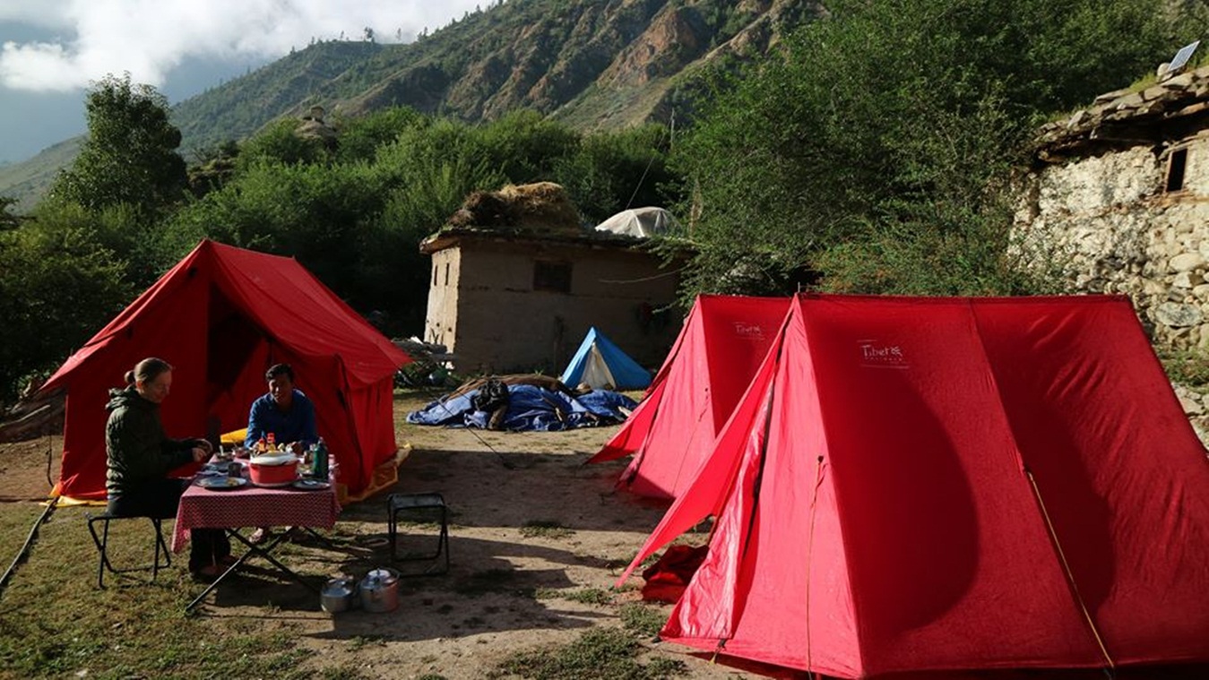
It takes a mere 45 minutes flight from take off to touch down until we get to Simikot from Nepalgunj. The trip is a thrill ride through the ridges and ravines in the spectacular mountains. Landing at the Simikot Airport is no less adventure as it is just a graveled airstrip. You feel like you are in a different realm because of the sudden rise in altitude and sudden fall in temperature. To leave behind the scorching hot climate behind, to be in a tiny mountain village and to be breathing cool and fresh air gives you adrenaline rush and refreshing feel. You are going to spend your night in the tented camp.
The day starts with the hike of about an hour. It is a short ascent to a pass which is approximately at the altitude of 3150m. From there it is a descent of about an hour to Majgaon. The trek has to go through the pine forest where you can see local Hindu and Buddhist people in their traditional attire accompanied by their herds of cattle. The cattle carry the load for the people in this part of the world because there are no other modes of transport. If they are not with their cattle the people carry their loads on their backs and take them all the way up. Once you go past Majgaon, the track gets uneven. One corner it is descent and it is ascent the next corner. This particular topography is called Nepali flat. It is green and lush than what you will see a little higher. When you decide to call it a day, your night will be spent in a tent
The sixth day of the trek is less work and more fun. The trek is going to be unusual one for some in that the track keeps altering the elevation within matters of a few hundred meters. The trail stretches alongside the Karnali River. There are going to be times when you will be looking down on the river working its way through narrow gorges and high rocky slopes and there will be moments when you find yourself walking right at the bank of the river. This is how the track has wound up. You will get to closely observe the pattern of cultivation there as your trek continues along the farming area of the locals. Most of them grow barley, buckwheat, potatoes and rice. Since your day is done early on the sixth day you can take out some time for hot spring bath. It is going to take a mere 30 minutes of your hiking day to get to the spring from Kermi Village. Kermi Village is first of the many Buddhist villages you are going to run into during your trek. The village lives of agriculture. It has two monasteries, Lakiyo Gompa and Lhundrup Choeling Gompa. The former is a few centuries old and is 45 minutes away from where camp will have been set. The latter one is relatively new and was built less than a hundred years ago. It takes 30 minutes to get there from the camp. The monasteries are not often visited by the tourists. You will see off your day and spend your night in a tent. The howls of jackals and hyenas keep reminding you that you are at the lap of the nature.
The track that takes you to Yalbang is flat and a steep ascent until you arrive at a small pass. After a walk of two hours, that is. The trail goes alongside the fields with different species of lizards and other creatures traversing your path. You cross the pass on a big iron suspension bridge dangling over the Sali River. It is all descent from this point forward. You might want to spend few extra minutes here in the cafes sipping at your cup of coffee or nibbling some cookies. The trek gets only better from here as there are beautiful pine trees above your head and emerald Karnali down the hill. Do not be surprised if you bump into caravans of mules and dzopas (crossbreeds of yaks and cows). They are the local villagers Simikot and Nyinba Valley travelling to and from Taklakot, a trade hub across the Tibetan border. Yalbang has so many places and heritages to offer that you could easily spend an extra day here. Namkha Khyung Dzong Monastery is one of them. Right in the front yard of the monastery you will be welcomed by a mammoth rock with Tibetan mantra written all over it. The monastery also happens to be the largest monastery in the region which is sheltering about 130 monks. The monastery originally comes from the Nyingmapa Lineage, the oldest Buddhist lineage. Legend has it Nyingmapa Lineage was founded by a great magician Guru Rimporche around the 7th century. The monastery has a huge statue of Shakyamuni Buddha and other smaller statues along with that of Guru Rimporche. The monastery also runs a school and a clinic. If you ask a monk he will be more than happy to show you around and later you can join others and chat with them over a cup of tea upstairs. Every morning at 7 and afternoon at 4, the monastery has customary prayer sessions. You can get soaked with the spiritual vibes by being a part of the ceremony. Please be quiet and remain behind the monks near one of the walls they had there. Spend your night in the tent with the melody of jackals and hyenas coming from the distant bushes.
The journey continues on as we catch up with the trail from where we left off. The path leaves the Karnali River well below when it reaches a tiny village Yangar. The path is mostly flat except at different parts of the journey there are three sided tunnel like trails that are carved out of gigantic boulders. The next thing that does not remain the same is the climate. The greenery begins to vanish and so do the smaller bushes. They give way to the pine trees and rocky hillocks in large part. You go across the Karnali River through a big wooden suspension bridge. The party is only getting started and you can tell that by looking at the trail that starts climbing the rocky mountain. It keeps climbing until it reaches the apex of the deep gorge. Your long time companion emerald green Karnali deep below the gorge still holds the same charisma and continues to keep you a company. You do not need to be surprised when you witness the ancient modes of trade still existing in same old fashion like the sheep carrying the sacks of salt on their backs. You may come across the big army tents set up in a few places. They are the mobile restaurants and cafeterias serving tea, coffee and quick snacks.
It consumes 3-4 hours of your trip before you reach Muchu. If you have energy left in your body and you want to be in Tumkot, you have to brace yourself for one additional hour of walk. Tumkot lies in the sideline of the main trail which dissects a small market right into two. Tumkot is to the north of the same market. Some 20 minutes walk from there, to be specific. The village is the proud owner of Dhungkar Choezom Monastery, which is affiliated to Shakya Lineage. It is considered one of the important monasteries in the Tibetan region. The monastery sits itself on top of a rocky mountain which takes about 20-30 minutes’ walk from the foot of the mountain. Dhungkar Choezom Monastery is the only Shakya monastery in Humla as there are only a few of such monasteries throughout the country. Should the curator of the monastery be available he will give you insight on every minute detail that the monastery has in its bosom. It is a heart wrenching to see that the monastery is in a bad shape and needs an immediate renovation though.
The track continues to go up. At times it gets even steeper. It will not be long before you feel the change in climate, vegetation and the landscape. After a few miles of hike the change begins to mark its authority. The landscape becomes more rocky and desolate. The trees that you see are not pine trees anymore. They are now short and low junipers. You catch up with the trail that is under construction. On the other end of the road is a village Pani Palwang with some tea houses which is a perfect place for a short time out and a cup of tea or lunch. The other reason that makes you wanna stop here for a breather is that it is just an hour and half from here to Yari or even Thado Dunga. Your overnight stay here will be in the tent which by the way is going to feel like nothing less than a five star hotel suite after all the hard work you put in.
The tenth day is “a tough day at work” thing as the hike is going to be long and tiring. And as if that’s not enough, it is going to reach the altitude of 4620 m when you are through the Nara La. The trees are gone by now and the landscape looks more like that of Tibet. Every few hundred meters you bump into the herd of dzopas, mules and even yaks. The bigger yaks specifically might catch your attention. The ascent gets vigorous after Thado Dunga. You might want to stop for a cup of tea here before you move ahead. And on top of that, there is still two more hours before you have reached the pass. And the last thing you want to see on your way is the residue of snow because that is only going to add few more agonizing hours to your trek. Even after the Nara La is in your sight the job will only be half done because it is not easy to seal the deal due to altitude factor.
Not to worry though. You can see the piles of stones, which are meant to bring good luck on you, prayer flags and prayer chants looming in the air with the strong breeze. What’s more! You are instantly captivated by the breathtaking view of Tibet on the one side and spectacular view of Yari Village down below. You will find barren mountains in brown, copper, ash and dark yellow colors as far as you can see. From here on, it is a shaky descent down until you find yourself standing in the border of Nepal and Tibet. The choice is yours as to if you want to play it safe and go through the dirt road which takes a bit longer or take a steep short cut. Your stay in tent is going to be like nothing you have ever done before.
A big iron bridge bids you adieu from Hilsa. Across the bridge is your long lost friend waiting to reunite with you, the Karnali River that is. You move along a narrow trail that winds its way up until you connect with the main route on the higher slope. The trail stretches alongside the Karnali River all the way to Manepeme. The path continues to put your physical strength to test with ups and downs. The landscapes, barren mountains and their iridescence blow your mind away and you have a little or no time to feel tired. And no prizes for guessing, you will be spending your night in a tent.
The climbing up continues on the twelfth day too. After about a walk of couple of hours there is a choice at your disposal. You choose between a small path that stays at the same level for a while and the wider path that starts going up immediately. The benefit of sticking to the narrower trail is that it takes you to a meditation cave, Ya Yip Phuk. This cave holds an old but important tale about the history of Buddhism. Lotsawa Rinchen Sangpo (985-1055 AD), a famous translator of Buddhist scriptures, meditated in this very cave. He also led the movement that revived the cultural exchange between India and Tibet. It ultimately led to the promulgation of Buddhism in Tibet. Also, the trail is teeming with lush and green vegetation. You can find rampant juniper trees along with some other shorter bushes.
You need to keep going up until you have arrived at Lamka La (4300m). The good news is the going gets a lot smoother from there on as the descent commences all the way to Til. As you get closer, you will find chörtens (stupas). The first sign of the village is the white buildings attached to the slopes. That has got to be the monastery with some retreat houses in the perimeter of the monastery. But you still have some time before you see the actual human settlements. The houses are perfectly colored to camouflage in the surroundings. By the time you have arrived at Til, you will find the environment has gotten green veils for it. The soil is fertile and you can tell that from the view of birches and terraced barley fields. Both of them look bright yellow in September-October. Two beautiful snow mountains have your back at all times.
Til is a beautiful Tibetan village like any other village in Limi Valley. The gateway to the village is a chörten. The villagers still wear their traditional dresses. Men wear a long thick brown coat, with one sleeve down and the women wear a long brown or blue dress with a colorful apron made from yak wool. They keep their heads covered with a long colorful cape. They have beautiful jewelry with big turquoise stones. The senior citizens spend most part of their day in spiritual activities, spinning around prayer wheels and humming “Om Mani Padme Hum” meaning roughly “blessed is the jewel in the lotus”. This mantra (chant) is believed to be possessed by Avalokitesvara, the buddhisatva (a Buddhist half god) who supposedly stays on Earth to anchor humanity to enlightenment and compassion. When you call it a day, you head to a tent and get a sound sleep.
The day ends with few hours of daylight to spare. This gives you the wonderful opportunity to wander around the village and have a look around the monasteries. The Limi River fills Karnali’s shoes as Limi River accompanies your trail. The walk is relatively easy and smooth. Keep an eye on the vicinity around you because you never know when those highly endangered species are going to show up. You do not want to miss out on such an opportunity. With luck on your side, you might come across mountain goats, snow leopards, and even blue sheep. The village is camouflaged into the environment so much so that you find it hard to locate at once. Once you go through the chörten you will see a big mani wall, mani walls are low walls built up with many stones with holy mantras and Buddhist deities carved on them. The village is the shelter to a 14th century monastery Rinchenling Gompa. The monastery is affiliated to Kagyugpa Lineage. Rinchenling Gompa is the holiest gompa in the region and is also the centre of religious activities in the Limi Valley. The monastery is very well taken care of with the help of Nepal Trust. It offers a great many things to visit inside. The main hall has a well decorated idol of Shakyamuni Buddha. Other rooms have smaller statues, a completed version of Kenjur (the Buddhist scripture), masks and costumes used during different cultural carnivals. They do not charge you for the entrance but you have to pay 500 NRS for the picture. Your stay overnight will be at one of the teahouses.
It is relatively a relaxed trek of four hours. The companionship of Limi River makes every single second worthwhile. Jang is the third and the last village of Limi Valley. And like all other village it is nothing short of majesty, surprises and beauty. As far as Jang is from the modern hustle and bustle and as free as it is from the modernism, Tibetan cultures come alive here at their purest. Jang, too, has a beautiful gompa which you can visit. The charge is free but like in Halji they will charge you a nominal fee of 500 NRS. The night will be spent in at one of the teahouses.
The best part about the trek now is that until Kermi there is no human settlements. It is going to be you and the most surreal landscapes. With that said, the trail gets tougher at times and you are going to have to cross quite a few rivers and streams. The trail remains slow and steady and goes up until Talang. Talang provides you a fair bit of leveled ground to camp at. You will be staying here in a tent overnight.
The sixteenth day takes you to the highest point of the tour. You go past Nyalu La pass which is approximately at the altitude of 4940 meters from the sea level. Your work way up the pass is surely going to be a daunting task. However, it is once in a life time opportunity to get to as high as 5000 meter and you want to take your trekking experience to the whole new level. Snow on the trail, 360 degree view of Humla and Tibet, the glimpse of glorious mountains like Mount Saipal (7031m), and Mount Kailash (6714m) make you want to push the limits. The path climbs down after you are beyond and across the pass. The altitude plummets to 4630 meters by the time you are in Lake Selma Tso. The downward slope continues on its course all the way down to Shinjungma which is also the campsite for the day sixteen. The changing vegetation and climate, the Sali River, steep slopes, Mount Kailash and the overnight stay in the tent are the salient features of this particular day.
Your first day in the human settlements in days after your trek started. You will get back to Kermi Village today. You are in the altitude below 3000 meters after long. The walk does not get any better because you will be treading on the solid grounds amidst pine and birch trees and Sali River by your side. The trail takes you to the Karnali River and your parade heads eastbound. You can relax a little bit here and dip your tired body into the hot springs before seeing off your day in a tented camp.
The day begins with few ups and downs along the road. The walk up to Darapuri (2300m) and Majgaon(2290m) is nice and smooth. It is after Majgaon that the trail decides to turn hostile. It is a two hours walk up the hill from the Karnali River until you reach a pass at the height of 3000m. From there on, it is half an hour walk to Simikot. You get to drink refreshing soda or drinks in Simikot and even hot water shower. The night number 18 will be spent in a tent.
With the end of day number 18, trek to Limi Valley comes to an end. It is a long way back to Kathmandu via Nepalgunj with some life long memories of the tour. You will be taking an aerial route to get back to Kathmandu. You will leave Humla in the earliest flight possible. You will have spare time to scan through the market in Thamel. After about two weeks and half you will be spending your night in a cozy hotel suite.
Your trip concludes here and you will fly for your respective destinations from Tribhuvan International Airport.
Cost Included
* Documents: All necessary paper work and permits (Simikot special permit, park entrance permits and TIM’s card).
* Transportation: All airport arrival/departures transfer, road-head transportation and Kathmandu to Nepalgunja-Simikot and return flight to Kathmandu
* Activities: Flying, hiking and trekking as per the itinerary.
* Accommodation: 3 night hotel in Kathmandu, 1 night hotel in Nepalgunj on twin sharing and 15 night’s home-stay/tented accomodation in mountain on twin sharing or multi – share bedroom.
* Food: 3 meals a day (Breakfast, Lunch and Dinner) during you’re staying in mountain.
* Staffs: Leader/Guide and supporters and their daily wage, food, and accommodation
* Company and Government’s service charge: All applicable Government taxes and official service charges. And Crew’s, daily wages/salary, food, equipment and road transportation
Cost Excluded
* Your international flight
* Travel/medical insurance coverage personal accidents, medical and emergency Helicopter rescue
* Personal travel and trekking equipments
* Lunch and dinner while in city
* Items of a personal nature such as normal drinks, hot shower, dessert, laundry, internet and phone call.
* Expenses occurred due to unavoidable Events i.e. road wrecks, flight delays etc.
*Temple and monastery entrance fees
* Tips/Gratuities for trekking crews
* Optional activities
* Unforeseen expenses which are out of control by Nepal Adventure Point
Trip Notes
Please request our Trip Note advice and detailed itinerary.